
INTERAKSI FAKTOR KENDALI TEKTONIK, PERMUKAAN LAUT DAN PERUBAHAN KLIM DI DAERAH TELUK KLABAT, KABUPATEN BANGKA INDUK, BANGKA
DOI:
https://doi.org/10.33332/jgsm.geologi.v19i1.191Abstract
The study of the Quarternary deposits in Klabat gulf areas was based on the analyses of the sedimentology and stratigraphy of fifteen borehole information obtained along west to east. The penetration of the bore head varied from 3.50 to 16.80 m from + 21 m to - 4 m of sea-level. Whereas, the Quarternary sediments in the studied area can be divided into seven sedimentary environments, consisting of alluvial fan (FKa), swamp (FRw), floodbasin (FCb), deltaic (FDt), sand beach (FPp), nearshore (FLdp), and nearshore to offshore (FLdp to FLlp) deposits. Based on the lateral and vertical sedimentary environment correlations, the Quaternary stratigraphic succession can be divided into four sedimentary intervals (IP I to IV). Each interval is typically for topography and elevation changes which is controlled by changes of the sedimentary environment systems. The controlling main factor of the sedimentary environment system changes was regional and local tectonics. Changes in tectonic regime are important upon a tidal flat sedimentation.
Â
Keywords: facies, paleoenvironment, tectonic
Downloads
References
INTERAKSI FAKTOR KENDALI TEKTONIK, PERMUKAAN LAUT DAN PERUBAHAN KLIM DI DAERAH TELUK KLABAT, KABUPATEN BANGKA INDUK, BANGKA
S. Hidayat dan H. Moechtar
Pusat Survei Geologi
Jl. Diponegoro 57, Bandung 40122
E-mail: contact@grdc.esdm.go.id
SARI
Studi yang dilakukan pada endapan Kuarter di Teluk Klabat meliputi analisis sedimentologi dan stratigrafi terhadap informasi lima belas hasil pemboran yang dilakukan di sepanjang lintasan berarah barat - timur. Kedalaman pemboran berkisar antara 3,50 hingga 16,80 m dari elevasi + 21 m hingga - 4 m dari permukaan laut. Selanjutnya, sediment Kuarter tersebut dapat dibedakan menjadi tujuh lingkungan pengendapan, terdiri atas endapan-endapan kipas alluvium (FKa), rawa (FRw), cekungan banjir (FCb), delta (FDt), pasir pantai (FPp), laut dekat pantai (FLdp), dan laut dekat pantai hingga laut lepas pantai (FLdp hingga FLlp). Didasari korelasi perubahan lingkungan pengendapan secara mendatar dan tegak, rangkaian stratigrafi Kuarter tersebut dapat dibedakan menjadi empat interval pengendapan (IP I-IV). Setiap interval dicirikan oleh berubahnya topografi dan elevasi yang dikontrol oleh berubahnya sistem lingkungan pengendapan. Faktor pengendali utama perkembangan sistem lingkungan pengendapan tersebut adalah tektonik regional dan lokal. Perubahan pada rezim tektonik sangat penting pada proses pengendapan sedimentasi di teluk.
Kata kunci: fasies, lingkungan purba, tektonik
ABSTRACT
The study of the Quarternary deposits in Klabat gulf areas was based on the analyses of the sedimentology and stratigraphy of fifteen borehole information obtained along west to east. The penetration of the bore head varied from 3.50 to 16.80 m from + 21 m to - 4 m of sea-level. Whereas, the Quarternary sediments in the studied area can be divided into seven sedimentary environments, consisting of alluvial fan (FKa), swamp (FRw), floodbasin (FCb), deltaic (FDt), sand beach (FPp), nearshore (FLdp), and nearshore to offshore (FLdp to FLlp) deposits. Based on the lateral and vertical sedimentary environment correlations, the Quaternary stratigraphic succession can be divided into four sedimentary intervals (IP I to IV). Each interval is typically for topography and elevation changes which is controlled by changes of the sedimentary environment systems. The controlling main factor of the sedimentary environment system changes was regional and local tectonics. Changes in tectonic regime are important upon a tidal flat sedimentation.
Keywords: facies, paleoenvironment, tectonic
ACUAN
Aleva, G.J.J., 1972. Aspects of the historical and physical geology of the Sunda shelf essential to the exploration of submarine tin placer. Geol. En Mijn 52 (2) : 79-91.
Aleva, G.J.J., Bon, E.H., Nossin, J.J. & Sluiter, W.J., 1973. A contribution to the Geology of Part of the Indonesian Tinbelt: the Sea Areas Between Singkep and Bangka Islands and Around the Karimata Islands. Geol. Soc. Malaysia, Bulletin 6, July 1973 : 257-271.
Andi Mangga, S. dan Djamal, B., 1994. Peta Geologi Lembar Bangka Utara, Sumatera. Skala 1:250.000. Pusat Penelitian dan Pengembangan Geologi, Bandung.
Choi, K. dan Kim, Sung-Pil, 2006. Late Quaternary evolution of macrotidal Kimpo tidal flat, Kyongi Bay, west coast of Korea. Abstract, Marine Geology, Vol. 232, Issues 1-2, 17-34.
Http://www.sciencedirect.com/science?_0b=ArticleURL&_udi=B6V6M-4KKWW4G-&_user=10&_rdoc=1&_fm t=&_ ori g=search &_so.
Cohen, K.M., Gouw, M.J.P. and Holten, J.P., 2003. Fluvio-deltaic floodbasin deposits recording differential subsidence within a coastal prism (central Rhine-Meuse Delta, The Netherlands. In: Blum, M.D., Marriott, S.B. and Leclair, S.F. (Eds.), Fluvial Sedimentology VII. Int. Assoc. of Sedimentologist, Blackwell Scientific, 40-68.
Donaldson, A.C., 1974. Ancient deltaic depositional recognized in Pennsylvania rocks of northern Ohio River valley. In: Dohanhue, J. and Rollins, H.B. (eds.), Conemaugh (Glenshaw) Marine Events, Field Guidebook, Pittsburgh Geological Society : F-1 to F-11.
Elliott, T., 1986. Deltas. In: Reading, H.G. (ed), Sedimentary environments and facies. Oxford, Blackwell Scientific Publications : 113-154.
Harsono, R., 1974. Pengaruh gerak-gerak Kuarter terhadap akumulasi sekunder bijih timah di pulau Bangka. PN. Timah, Dinas Eksplorasi UPTB, PIT ke 3 IAGI, 12 h.
Hidayat, S., Pratomo., I dan Moechtar, H., 2008. Keterdapatan endapan plaser timah dalam sistem lingkungan pengendapan Kuarter di sungai Selan-Celuak, Kab. Bangka Tengah. “Jurnal Puslitbang Teknologi Mineral dan Batubara “TEKMIRAâ€. (Dalam proses penerbitan).
Inden, R.F., Coalson, E.B. dan Horne, J., 2002. Permian Tectonic, Eustacy, and Climates in Wyoming. AAPG Hedberg Conference, “Late Paleozoic Tectonic and hydrocarbon Systems of Western North America - The Greater Ancestral Rocky Mountainsâ€, 2 p.
Inman, D.L. dan Nordstrom, C.E., 1971. Tectonic Classification of Coasts. Abstract, 4 p. Http://w3.salemstate.edu/~lhanson/gls214/gls214_tec_clas.htm
Katili, J.A. and Tjia, H.D., 1969. Outline of Quaternary tectonics of Indonesia. Bulletin NIGM . 2 ( 1) : 1-10.
Miall, A.D., 1978. Facies types and vertical profile models in braided river deposits: a summary. In: Mial, A.D. (ed), Fluvial Sedimentology. Canadian Society of Petroleum Geologist, Memoar 5 : 1-47.
Miall, A.D., (1992). Alluvial Deposits. In: A.D. Miall and N.P. Jones (eds.), Facies models response to sea level change. Geological Association of Canada, p. 119-142.
Moechtar, H., 2007. Runtunan stratigrafi sedimen Kuarter kaitannya terhadap perubahan global sirkulasi iklim dan turun-naiknya permukaan laut di lepas pantai barat kepulauan Karimata (Kalbar). Bulletin of Scientific Contribution, 5 (1) : 11-23.
Moechtar, H., Siswanto, R., Nitiwisastro, M., 1997. Karakter endapan plaser di P. Bangka kaitannya dengan perencanaan eksplorasi. Majalah Pertambangan dan Energi Edisi Khusus 1997 : 64-70
Nitiwisastro, N., Wibowo, W., Moechtar, H., 1995. Geological data in relation to the present and future exploration (Case study in Bangka and Belitung). Mining Indonesia Conference1995, Jakarta- Indonesia : 24pp.
Osberger, R., 1965. Catatan tentang geologi P. Bangka. Tidak dipublikasikan, Arsip Dinas Eksplorasi UPTB
Paczeoena, J. dan Poprawa, P., 2005. Eustatic versus tectonic control on the development of Neoproterozoic and Cambrian stratigraphic sequences of the Lublin-Podlasie Basin (SW margin of Baltica). Geosciences Journal 9 (2) : 117-127.
Reineck, H.E. dan Singh, I.B., 1980. Depositional Sedimentary Environment. Springer - Verlag, Berlin : 549 pp.
Silveira, O., Santos, V.F. dan Takiyama, L.R., 2007. The Morphologic Evolution of the Amazone Coastal Plain, Cabo Norte, Amapa, Brazil: The Need for Integrated Investigation on the internal Continental shelf, in Ocean Science (OS): Sedimentation Associated With Wet-Tropical Rivers: Interdisiplinary Linkages II: Posters, OS23D-01.Http://searchhanddiscovery.net/documents/abstracts/heddenberg2002vail/inden.pdf. http://www.agu.org/meetings/sm07/sm07-sessions/sm07_OS23D.html.
Silva, C.A., Souza Fhilo, P.M. Dan Gouvea Luiz, J., 2007. High-Resolution Subsurface Imaging and Stratigraphy of Quaternary Deposits, Marapanim Eustuary, Northern Brazil, in Ocean Science (OS): Sedimentation Associated With Wet-Tropical Rivers: Interdisiplinary Linkages II: Posters, OS23D-03. http://www.agu.org/meetings/sm07/sm07-sessions/sm07_OS23D.html.
Soehaimi, A. and Moechtar, H., 1999. Tectonic, Sea Level or Climate Controls During Deposition of Quaternary Deposits on Rebo and Sampur Nearshores, East Bangka-Indonesia. Proceedings of Indonesian Association of Geologist, The 28th Annual Convention, 91-101.
Tjia, H.D., 1970. Quaternary shorelines of the Sunda Land, Southeast Asia. Geol. En Mijn, (49) : 135-144.
Tjia, H.D., 1989. Quaternary Sea Level changes and Related Geological Processes in relation to secondary tin deposits. Workshop Seatrad, Pangkalpinang : 66 pp.
Yoshihiro, M., 2003. Sedimentary facies and tectonic movements within the horizon of the Pink Volcanic Ash Layer of the Osaka Group in southern Osaka Prefecture, Japan. Abstract, Science Linkes Japan, Japan Science and Technology Agency. Http://sciencelinks.jp/j-east/article/200402/ 000020040203A0871105.php
Walker, R.G., 1992. Facies, Facies Models and Modern Stratigraphic Concepts. In: A.D. Miall and N.P. Jones (eds.), Facies models response to sea level change. Geological Association of Canada :1-14.
MINERALOGI MATRIKS BREKSI GUNUNG API PLISTOSEN AKHIR – KUARTER BERDASARKAN DATA XRD DI DAERAH LOMBOK TIMUR, NUSA TENGGARA BARAT
S. Maryanto, R. Hasan, dan D.A. Siregar
Pusat Survei Geologi
Jl. Diponegoro No. 57 Bandung 40122
SARI
Batuan gunung api Plistosen Akhir hingga Kuarter yang termasuk ke dalam Formasi Kalipalung, Formasi Kalibabak, danFormasi Lekopiko tersingkap dengan baik di daerah Lombok Timur dan pada umumnya berupa breksi gunung api. Komponen breksi gunung api penyusun Formasi Kalipalung terdiri atas andesit, andesit porfiri, andesit basalan, basal, dan batuan terubah. Frekuensi kehadiran antara andesit dan basal hampir seimbang. Komponen breksi gunung api penyusun Formasi Kalibabak terdiri atas andesit, andesit porfiri, sangat jarang andesit basalan dan basal. Frekuensi kehadiran andesit sangat menguasai batuan. Komponen breksi gunung api penyusun Formasi Lekopiko terdiri atas batuapung dan sangat jarang andesit, selain berupa pasir dan pasir konglomeratan. Hasil pengujian XRD terhadap percontoh matriks breksi yang dipilih menunjukkan bahwa jenis plagioklas berkembang dari labradorit dan andesin pada Formasi Kalpialung dan Formasi Kalibabak menjadi andesin, oligoklas dan albit pada Formasi Lekopiko. Dari formasi tua ke muda, piroksen klino berkembang menjadi piroksen orto dan akhirnya piroksen tidak hadir. Mineral lempung monmorilonit terawetkan pada formasi yang berumur tua, semakin menghilang pada formasi ber mur muda atau digantikan oleh kaolinit. Berdasarkan hasil uji beda yang telah dilakukan tampak bahwa secara umum Formasi Kalipalung dan Formasi Kalibabak mempunyai kesamaan dalam ciri-ciri mineralogi. Di pihak lain , perbedaan nyata terjadi antara Formasi Kalipalung dengan Formasi Lekopiko, begitu pula Formasi Kalibabak dengan Formasi Lekopiko.
Kata kunci: Lombok Timur, matriks breksi, mineralogy
ABSTRACT
Late Pleistocene to Quarternary volcanic rock units of the Kalipalung, Kalibabak, and Lekopiko Formations are well cropped out at East Lombok area, composed predominantly of volcanic breccias. The volcanic breccia of the Kalipalung Formation composed of andesite, porphyry andesite, basaltic andesite, basalt, and altered igneous rocks fragments. The frequence of the occurrence of the andesites and basalts is balanced. The volcanic breccia of the Kalibabak Formation composed predominantly of andesite, porphyry andesite, and rarely basaltic andesite and basalt rock fragments. The volcanic breccia of the Lekopiko Formation composed predominantly of pumice and less of andesite rock fragments, as well as sand and conglomeratic sands. XRD analysis of selected volcanic breccias matrix shows that the plagioclase change from labradorite and andesine on the Kalipalung and Kalibabak Formation to andesine, oligoclase and albite on the Lekopiko Formation. From the old to young formations, the orthopyroxene and clinopyroxene change to orthopyroxene, and finally these minerals was dissapeared. The clay minerals of montmorilonite commomly preserved on the old formation, it dissapeared and replaced by kaolinite in the young formation. Based on the difference test between two means it appears that the Kalipalung and Kalibabak Formations are similar on their mineralogical characters. On the other hand, the Kalipalung Formatian has a real difference on the mineralogical character with the Lekopiko Formation, as well as the Kalibabak Formation with the Lekopiko Formations.
Keywords: Earth Lombok, breccias matrix, mineralogy
INDIKASI FENOMENA STRUKTUR GEOLOGI BAWAH PERMUKAAN DAERAH RENCANA TAPAK PEMBANGKIT LISTRIK TENAGA NUKLIR GUNUNG API GENUK DAN SEKITARNYA, JEPARA, JAWA TENGAH
S. Panjaitan dan Subagio
Pusat Survei Geologi
Jl. Diponegoro No. 57 Bandung 40122
SARI
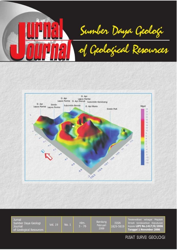
Umumnya anomali gayaberat di daerah penelitian terbagi atas dua kelompok yakni anomaly tinggi dengan kisaran nilai dari 37 mgal hingga 43 mgal dan anomali rendah dengan variasi nilai dari 10 mgal hingga 37 mgal. Anomali tinggi disebabkan oleh keberadaan batuan volkanik Kuarter dan anomali rendah meng-indikasikan keberadaan cekungan sedimen. Analisis kuantitatif, anomali tinggi merefleksikan keberadaan batuan volkanik Kuarter dengan rapatmassa 2,8 3 gr/cm yang relatif lebih tinggi dibanding rapatmassa batuan di sekitarnya. Selain itu di daerah rencana tapak di Ujung Lemahabang ini menunjukkan tidak dijumpai struktur patahan. Selanjutnya dalam radius 5 km dari daerah penelitian diperkirakan tidak terdapat capable fault. Dalam area radius 25 km, terdapat dua patahan yang terletak di lepas pantai dan tiga buah patahan lainnya terletak di sebelah barat daerah penelitian.
Kata kunci : Lemahabang, anomali gaya berat, cekungan sedimen dan patahan
ABSTRACT
Generally, gravity anomaly pattern in research area is devided into two groups, high anomaly with the value ranges from 37 mgal to 43 mgal, and low anomaly, varies from 10 mgal to 37 mgal. The high anomaly group might be caused by the existing volcanic Quartenary rocks, and the low anomaly group indicates a sedimentary basin. Based on the result of 3 quantitative analysis, the high anomaly group reflects the existing volcanic Quartenary rocks with density 2.8 gr/cm relatively higher than surrounding. Analysis also shows in the site plan of Ujung Lemahabang the predicted faults are not encountered. The area in radius 5 km from research area, predicted the capable fault not exist in radius 25 km, found two faults ofshore and three faults in western part of investigation area.
Keywords : Lemahabang, gravity anomaly, sedimentary basin arc fault
ACUAN
Edwards, C. Menzies, M. dan Thirlwall. 1991. Evidence from Muriah, Indonesia, for the interplate processes in the genesis of potassic alkaline magmas, Journal of Petrology, 32 (1) : 555-592, Oxford University Press.
Hamilton, W. 1979. Tectonic of Indonesian Region, Geo. Survey. Prof. Paper, U.S. Govt. Print. Office, Washington D.C.
Kadar, D. dan Sujiono. 1994. Peta Geologi Lembar Rembang, Jawa , Skala 1 : 100.000, Pusat Penelitian dan Pengembangan Geologi Bandung.
Sukardi, T. dan Wikarno, R. 1992. Peta Geologi Lembar Kudus, Jawa Tengah Skala 1 : 100.000. Pusat Penelitian dan Pengembangan Geologi, Bandung.
Sukardi, T. dan Budhitrisna, T. 1984. Peta Geologi Lembar Salatiga, Jawa Tengah, Skala 1 : 100.000, Laporan Terbuka. Pusat Penelitian dan Pengembangan Geologi Bandung.
Sidarto, Suriono, dan Sanyoto, P. 1999. Sistem Sesar Pengontrol Pemunculan Kelompok Gunung Api Muria Hasil Penafsiran Citra Landsat. Jurnal Geologi dan Sumberdaya Mineral Bandung.
Downloads
Published
Issue
Section
License
Authors who publish articles in Jurnal Geologi dan Sumberdaya Mineral (JGSM.Geologi) agree to the following terms:
- Authors retain copyright of the article and grant the journal right of first publication with the work simultaneously licensed under a CC-BY-NC or The Creative Commons Attribution–ShareAlike License.
- Authors are able to enter into separate, additional contractual arrangements for the non-exclusive distribution of the journal's published version of the work (e.g., post it to an institutional repository or publish it in a book), with an acknowledgment of its initial publication in this journal.
- Authors are permitted and encouraged to post their work online (e.g., in institutional repositories or on their website) prior to and during the submission process, as it can lead to productive exchanges, as well as earlier and greater citation of published work (See The Effect of Open Access)


