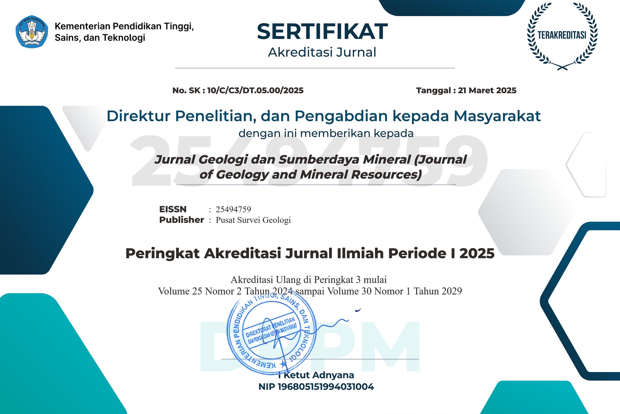
Jurnal Geologi dan Sumberdaya Mineral https://jgsm.geologi.esdm.go.id/index.php/JGSM <p><strong>Jurnal Geologi dan Sumberdaya Mineral (Journal of Geology and Mineral Resources)</strong> is an Indonesian scientific journal published by the Center for Geological Survey, Geological Agency, Ministry of Energy and Mineral Resources. The journal receives Indonesian or English articles. Those articles are selected and reviewed by our professional editors and peer reviewers.</p> <p>JGSM has been assigned as an Accredited Scientific Periodical Magazine by the Indonesian Institute of Sciences (LIPI) No. 596/Akred/P2MI-LIPI/03/2015 in 2015, followed by Kementerian Riset dan Teknologi / Badan Riset dan Inovasi Nasional No. 200/M/KPT/2020 in 2020. The journal is indexed in <a title="portal_garuda_IPI" href="http://id.portalgaruda.org/?ref=browse&amp;mod=viewjournal&amp;journal=10104" target="_blank" rel="noopener">Indonesian Publication Index (IPI)</a>, <a title="isjd" href="http://isjd.pdii.lipi.go.id/index.php/public_no_login/index_direktori" target="_blank" rel="noopener">Indonesian Scientific Journal Database (ISJD)</a>, <a href="http://dx.doi.org/10.33332">Digital Object Identifier (DOI)</a> and <a title="google_scholar" href="https://scholar.google.co.id/citations?user=nXMHIYUAAAAJ&amp;hl=en" target="_blank" rel="noopener">Google Scholar</a>, the contents are freely available in electronic version. JGSM is published quarterly in February, May, August, and November.</p> <p><a title="issn" href="http://issn.pdii.lipi.go.id/issn.cgi?daftar&amp;1402376294&amp;1&amp;&amp;" target="_blank" rel="noopener"><strong>ISSN : 0853-9634 (print)</strong></a></p> <p><a title="eissn" href="http://issn.pdii.lipi.go.id/issn.cgi?daftar&amp;1485227549&amp;1&amp;&amp;" target="_blank" rel="noopener"><strong>e-ISSN : 2549-4759 (online)</strong></a></p> <p><strong><em><strong>DOI Prefix: </strong></em><a title="JGSM" href="https://doi.org/10.33332">https://doi.org/10.33332</a><br /></strong></p> Pusat Survei Geologi en-US Jurnal Geologi dan Sumberdaya Mineral 0853-9634 <p>Authors who publish articles in <strong>Jurnal Geologi dan Sumberdaya Mineral (JGSM.Geologi)</strong> agree to the following terms:</p><ol><li>Authors retain copyright of the article and grant the journal right of first publication with the work simultaneously licensed under a <strong>CC-BY-NC</strong> or <strong>The Creative Commons Attribution–ShareAlike License.</strong></li><li>Authors are able to enter into separate, additional contractual arrangements for the non-exclusive distribution of the journal's published version of the work (e.g., post it to an institutional repository or publish it in a book), with an acknowledgment of its initial publication in this journal.</li><li>Authors are permitted and encouraged to post their work online (e.g., in institutional repositories or on their website) prior to and during the submission process, as it can lead to productive exchanges, as well as earlier and greater citation of published work (See <a href="http://opcit.eprints.org/oacitation-biblio.html" target="_blank">The Effect of Open Access</a>)</li></ol> Karakteristik Lava Bantal – Peperit – Hialoklastit Sukabumi Selatan : Wawasan Baru tentang Produk Gunungapi Bawah Laut di Selatan Pulau Jawa https://jgsm.geologi.esdm.go.id/index.php/JGSM/article/view/780 <p>Di bagian selatan Pulau Jawa bagian barat dijumpai batuan gunungapi berumur Paleogen-Neogen, dengan pola sebaran relatif memanjang timur – barat. Batuan tersebut dimasukkan ke dalam kelompok batuan vulkanik dan Magmatic Arc berumur Eosen Akhir – Miosen Awal. Keberadaan batuan gunungapi tersebut merupakan fenomena menarik untuk dikaji, diantaranya kehadiran batuan gunungapi Formasi Jampang, Tuf Anggota Cikarang dan Lava Anggota Ciseureuh berumur Miosen awal di daerah Sukabumi Selatan. Makalah ini bertujuan untuk melakukan identifikasi batuan gunungapi bawah laut di daerah penelitian, berdasarkan kenampakan makroskopis, yang dihasilkan oleh interaksi antara lava-air-sedimen. Penelitian ini berbasis pada analisis data lapangan, terutama pengenalan produk batuan yang dihasilkan dari interaksi lava-air-sedimen yang ditemukan pada beberapa lokasi, serta dilakukan pengamatan petrografi pada beberapa sampel batuan untuk melihat hubungan antara skala makroskopis dan mikroskopisnya. Hasil interaksi lava dengan air-sedimen menghasilkan beberapa produk berupa lava bantal, peperit, dan hialoklastik, yang dijumpai di beberapa lokasi; seperti Sungai Cikaso - Surade, Lengkong dan Waluran – Jampang. Hasil identifikasi tersebut menunjukkan bahwa pada saat terjadi aktivitas vulkanisme, lava berinteraksi dengan air dan sedimen yang masih basah dan tidak terkonsolidasi.</p> <p>Katakunci: Gunungapi bawah laut, hialoklastit, interaksi air-sedimen, lava bantal, peperit, Sukabumi selatan.</p> <p> </p> Agustina Djafar Indyo Pratomo Wilda Aini Nurlathifah Copyright (c) 2024 Agustina Djafar, Indyo Pratomo, Wilda Aini Nurlathifah http://creativecommons.org/licenses/by-nc/4.0 2024-01-03 2024-01-03 25 1 1 8 10.33332/jgsm.geologi.v25i1.780 Paleogene Deposits Distribution of the Kampar Block, Central Sumatra Basin https://jgsm.geologi.esdm.go.id/index.php/JGSM/article/view/809 <p>As the most prolific basin, Central Sumatra Basin is a very mature basin for hydrocarbon exploration. Most of the productive reservoir came from Neogen deposits therefore the stratigraphic reconstruction for depositional environment distribution focused on this deposits. Meanwhile the Paleogene deposits distribution and gross depositional environment (GDE) has not been explore further especially on the southern part on the basin.</p> <p>Paleogen deposits like Kelesa Formation is a syn rift deposition which was deposited in the center of the basin. The lithofacies development of the Kelesa Formation consist of 3 major lithofacies associations: (1) thick-bedded mudstone, (2) Interbedded sandstone and conglomerate, (3) Interbedded sandstones and mudstones. The thick-bedded mudstone is deposited in deep lake setting; interbedded sandstone and conglomerate is interpreted as alluvial fan deposit and interbedded sandstones and mudstones as a fluvial channel.</p> <p>GDE map of Kelesa Formation indicate that sandstones facies developed in fluvial and alluvial fan setting near the basin boundary consider as a potential for future hydrocarbon exploration.</p> <p>Keywords: Kelesa Formation; lithofacies; gross depositional environment; Paleogene deposits</p> Fikri Muhammad Fiqih Abdurrokhim Budi Muljana Copyright (c) 2024 Fikri Muhammad Fiqih, Abdurrokhim, Budi Muljana http://creativecommons.org/licenses/by-nc/4.0 2024-01-15 2024-01-15 25 1 9 18 10.33332/jgsm.geologi.v25i1.809 Mikrofasies batugamping Formasi Tokala Daerah Ululere dan Sekitarnya, Kabupaten Morowali Sulawesi Tengah https://jgsm.geologi.esdm.go.id/index.php/JGSM/article/view/786 <p><em>Penelitian mikrofasies batugamping telah dilakukan pada Formasi Tokala Daerah Ululere. Formasi Tokala terendapkan pada lingkungan laut dalam hingga laut dangkal. Tujuan utama penelitian ini yaitu untuk menentukan lingkungan pengendapan batugamping dengan pendekatan zona mikrofasies. Metode penelitian yang digunakan adalah pendekatan secara analisis kualitatif dengan menggunakan data lapangan dan dilanjutkan dengan analisis laboratorium. Penentuan mikrofasies batugamping pada lokasi penelitian menggunakan analisis standar mikrofasies dengan sayatan tipis. Analisis petrografi terhadap sepuluh sampel batugamping menunjukan beberapa litologi meliputi mudstone, wackestone, packstone dan batugamping kristalin dengan kelimpahan foraminifera planktonik. Berdasarkan hasil analisis petrografi memperlihatkan beberapa tipe mikrofasies batugamping yaitu wackestone bioklastika dengan foraminifera planktonik globigerinids, mudstone pelagis dengan foraminifera planktonik globigerinid, mudstone dengan mikrit dan mikrosparit, dan peloidal packstone. Mikrofasies ini terendapkan di beberapa lingkungan pengendapan yaitu lingkungan dangkalan dalam, tepi dangkalan dalam dan paparan terbatas. Ketiga lingkungan pengendapan ini memiliki energi yang rendah dan memiliki komposisi mikrit yang sangat banyak serta kelimpahan foraminifera plantonik</em><em>.</em></p> <p>&nbsp;</p> <p>Kata kunci: <em>mikrofasies, batu gamping, foraminifera plantonik, Formasi Tokala, kristalin</em></p> Arisona Nia Kurnia Praja Eldin Masri Muliddin Ali Okto Hasria Bahdad Copyright (c) 2024 Nia Kurnia Praja, Arisona, Eldin, Masri, Muliddin, Ali Okto, Hasria, Bahdad http://creativecommons.org/licenses/by-nc/4.0 2024-02-16 2024-02-16 25 1 19 30 10.33332/jgsm.geologi.v25i1.786 Prospecting CCS Project in Indonesia: A Case Study in Meratus Mountains, South Borneo https://jgsm.geologi.esdm.go.id/index.php/JGSM/article/view/784 <p>Long-term extensive carbon dioxide exposure inflicts diseases for humans and endangers the ecosystem. Carbon Capture and Storage (CCS) is a breakthrough to reduce CO2 in the atmosphere. The purpose of this study is to describe the CCS principles and suitability of this work in Indonesia, especially in the Meratus Mountains. The studied region is the major area of the Meratus Geopark. Selected ultramafic rocks from the Meratus Geopark were analyzed using X-Ray Fluorescence in the University of Tasmania. CCS project should consider the minimum implication for conservation strategy of geopark. Geologically, CCS is adapted through direct sequestration and carbon mineralization. Mafic-ultramafic lithologies are the best option for mineral carbonation. Most of the basaltic rocks in Indonesia are situated near active volcanoes that are heavily risky for CCS works. Ultramafic in the range of Meratus Geopark is clearly suitable for CCS because of its large expanse, far away from active volcanoes, without significant nickel mining activity. The project would promote geohazards and climate change issues of Meratus Geopark. In-situ CSS mineral carbonation should be located avoiding the Sultan Adam Mandiangin Serpentinite Geosite to nourish the geoconservation of Meratus Geopark. A successful CCS adaptation would be good evidence for the Indonesian government implementing the Paris Agreement.</p> <p>Keywords: Carbon Capture and Storage, In-situ mineral carbonation, ultramafic, Meratus Geopark.</p> Ronaldo Irzon Hanang Samodra Sam Permanadewi Copyright (c) 2024 Ronaldo Irzon, Hanang Samodra, Sam Permanadewi http://creativecommons.org/licenses/by-nc/4.0 2024-02-19 2024-02-19 25 1 31 40 10.33332/jgsm.geologi.v25i1.784 Temuan Endapan Paleotsunami di Pulau Ternate: Bersiap untuk Selamat https://jgsm.geologi.esdm.go.id/index.php/JGSM/article/view/770 <p>Pulau Ternate adalah pulau gunung api di atas Laut Maluku. Secara geologi, pulau ini terbentuk sebagai konsekuensi dari pertemuan lempeng Eurasia, Filipina, dan Pasifik. Masyarakat di pulau ini sangat paham tentang bencana gunung api, namun mereka belum pernah mendengar bahwa tsunami pernah melanda sebagian pulau ini. Suatu penyelidikan menemukan adanya endapan paleotsunami yang tertutupi oleh produk letusan gunung api. Hal ini menunjukkan, bahwapulau ini pernah terlanda tsunami di masa lalu. Terdapat sekitar lima unit endapan paleotsunami pada singkapan di bagian barat Pulau Ternate. Setiap lapisan menunjukkan karakter tsunami yang berbeda, baik kekuatannya maupun waktu kejadiannya. Endapan paleotsunami tertua memiliki ketebalan 5,5 cm, terdiri dari beberapa sekuen pengendapan yang mengindikasikan gelombang tsunami yang datang lebih dari satu kali. Sedangkan endapan paleotsunami yang lebih muda hanya memiliki satu sekuen pengendapan yang menandakan hanya ada satu gelombang tsunami yang datang ke lokasi tersebut. Berdasarkan tempat ditemukannya, yakni di bawah produk Gunung api Gamalama yang diketahui terjadi pada tahun 1907, memberikan informasi bahwa umur endapan tsunami tersebut lebih tua dari tahun 1907, yang menurut katalog tsunami, bisa saja terjadi pada tahun 1846, 1854, 1857, 1858, 1859 atau 1889. Tulisan ini ingin memberikan pemahaman tentang tsunami yang terjadi sebelum usia masyarakat yang tinggal di daerah tersebut. Sehingga mereka bisa mempersiapkan diri sedini mungkin untuk meminimalisir resiko dampak yang bisa terjadi dan selamat jika tsunami datang di kemudian hari.</p> <p>Katakunci: Endapan tsunami, paleotsunami, produk letusan gunung api, Ternate.</p> Yudhi Cara Syahril Lukman Copyright (c) 2024 Yudhi Cara, Syahrir Lukman http://creativecommons.org/licenses/by-nc/4.0 2024-02-19 2024-02-19 25 1 41 53 10.33332/jgsm.geologi.v25i1.770 Preliminary Result on Optimum Seed Generation Bandwidth for Object-Based Image Segmentation (OBIS) of Porphyritic Igneous Thin Sections https://jgsm.geologi.esdm.go.id/index.php/JGSM/article/view/698 <p>Crystal size distribution (CSD) analysis is one of many methods for studying the crystallization history of magma. It involves labor-intensive digitation of all crystals, which may prolong the processing of large data sets. This study presents a preliminary result of Object-Based Image Segmentation (OBIS) as a semi-automatic approach in crystal digitation. Five data sets containing 9 photomicrographs of porphyritic igneous rock thin sections were processed using SAGA GIS. The procedure produced an optimum bandwidth equation of y = 38.455 ln(x) + 114, where x is the average size of sampled crystal in mm. Segmentation tests on another sample using the formula returned good and consistent results with important notes on sensitivity to textures which may result in crystal segment separation, such as fractures, veins, and sieve, as well as the inability to separate all groundmass crystals. Even though it shows good results, this formula only applies where the pixel-to-length conversion factor of 562.2 pixel/mm.</p> <p>Keywords: OBIS, SAGA GIS, Optimum bandwidth, Photomicrograph, Porphyritic igneous rock thin section.</p> Rio Priandri Nugroho Victoria Vania Blanca Widjaya Mohamad Roviansah Copyright (c) 2024 Rio Priandri Nugroho http://creativecommons.org/licenses/by-nc/4.0 2024-02-20 2024-02-20 25 1 55 63 10.33332/jgsm.geologi.v25i1.698